Trip Overview
Rolpa, lying in a mid - western part of Nepal, is one of the most backward districts in terms of modern infrastructure. However, it is regarded as one of the exciting potential tourism destinations in the country because of its nature, culture and political history. The district headquarters of Rolpa is Libang lies approximately 300 km west of Kathmandu. Kham Magaris the major inhabitants of the district followed by other groups like Brahmins, Chettri, Newar and Thakuri. Rolpa is the origin of the decade-long People’s War which claimed more than 16,000 people were killed during the civil war. Jaljala is one of the popular destinations in the district with immense tourism potentials. A detailed itinerary of a trek to Jaljala is given below:
Outline Itinerary
-
Day 1
Kathmandu (1,350 m) - Sulichaur (810 m) / (Drive by bus / 12 hrs) / Drive by Private Jeep / 10 hrs).
-
Day 2
Sulichaur- Fulibang by jeep drive then trek to Kotalbara (1,606 m) – Drive: 4 hrs, Trek 4 hrs = 8 hrs.
-
Day 3
Kotalbara- Ajambari commune village (2,217 m / 7 hrs trek).
-
Day 4
jambari Commune Village -Thabang Village (2,000 m / 1 1/2 - 2 hrs).
-
Day 5
Thabang village (The rest day / explore the whole village which is the biggest village in the region).
-
Day 6
Thabang village -Jaljala (3,107 m/ 6-7 hrs walk).
-
Day 7
Jaljala - Dharampani (3,900 m) - Majhibang (2,100 m / 3+4 = 7 hrs).
-
Day 8
Majhibang Rest Day / Explore the whole village.
-
Day 9
Majhibang -Jailbang-Sulichaur (810 m / walk: 2:30 hrs, Drive 4 hrs = 6:30 hrs).
-
Day 10
Sulichaur-Kathmandu by driving (Bus / Jeep = 12 hrs or 10 hrs).
Detailed Itinerary
-
Day 1
Kathmandu (1,350 m) - Sulichaur (810 m) / (Drive by bus / 12 hrs) / Drive by Private Jeep / 10 hrs).
The starting point of trek, Sulichaur, is connected by road from Kathmandu. Surface transport is the only alternative to reach Rolpa unless you charter a helicopter or you can fly to Bhairahawa and drive for six hours to reach Sulichaur. The hillside road drive is a joy with scenic attraction along the way. Night buses to Sulichaur leave from Gongabu Bus Park (new bus station) and you can reach Sulichaur early next morning. Sulichaur is both the starting and ending point of this trek. It is a hillside commercial hub of Rolpa district. Lying at an altitude of 810 m above sea level, Sulichaur lies near the confluence of Lungri Khola and Fagam Khola. According to locals, early rulers of Sulichaur, the Kham Rajas, used to give Capital punishment to guilty people at this very place. Medium range of accommodation is available at Sulichaur. -
Day 2
Sulichaur- Fulibang by jeep drive then trek to Kotalbara (1,606 m) – Drive: 4 hrs, Trek 4 hrs = 8 hrs.
The drive begins after breakfast at Sulichaur. The jeep drive on a graveled road passes through Sunchahari fall. Sunchahari fall (1,450 m) is one of the major attractions of the area. It can be reached after a drive of two and half hours from Sulichaur. Sunchahari is derived from two words – sun means gold and Chahari means search (Gold Searcher). Locals believed that gold used to flow in the stream in the past. After a drive of about half an hour, you reach Pobang – a small settlement ideal for tea and light snacks. There are a few teashops and a medical store Pobang. Fulibang, where the graveled road ends, is only half an hours of drive away. The trek starts after having lunch at Fulibang. The hike from Fulibang to Kotalbara is a gentle climb. After walking on the smooth trail for two and half hours, you reach Sirkyang which offers magnificent view of green hills, rivers and settlements below. A walk of about one and half hours from Sirkyang, takes you to Kotalbara (1,606 m) – the last destination for the day. Kotalbara is a small settlement with basic accommodation facility available. -
Day 3
Kotalbara- Ajambari commune village (2,217 m / 7 hrs trek).
This day is one of the most exciting days of the trek as you go through varieties of geographical conditions. After breakfast at Kotalbara, the walk passes through the normal trail till Pobang River. After crossing the suspension bridge over the river, the walk is mostly uphill. A walk of about four hours from Pobang River takes us to Pobang for lunch. Posbang is a small village with a few tea houses. After lunch, the walk passes through Dilbhanjyang (2,576m) – the highest point of the day – to reach Sandho River. You walk upstream through the river because there are no trails available. After navigating the River for about half an hours, you reach Ajambari Commune – the destination of the day. Ajambari Commune (2,217 m) is perhaps the only remnant of Maoist’s People’s Long War. Based in purely socialist concept, this commune, which was established in 2000 A.D. at the height of insurgency, consists of two houses. As many as 22 families used to reside here during insurgency. At present, only four families are living in the commune. These families don’t have private property. The stay in this commune will give you the insights of people’s war, their motivation towards socialism and their innovation. In order to sustain themselves, they are looking for the alternative economic activities for which they have already initiated some modern forms of agriculture such as Truffle mushroom and ground apple farm. -
Day 4
jambari Commune Village -Thabang Village (2,000 m / 1 1/2 - 2 hrs).
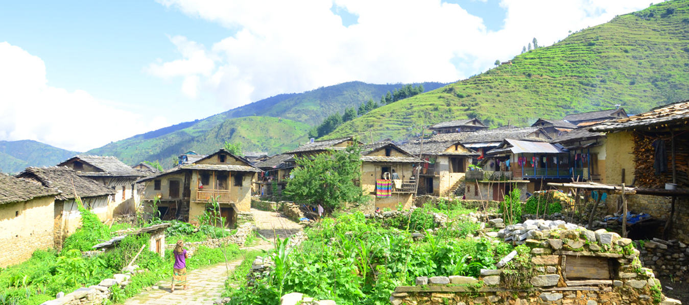
Morning can be spent by talking to ex-combatants about their experience about the People’s War. After lunch at Commune, the trek progresses toward Thabang village (2,000 m), popularly known as the headquarters of the People’s war. Thabang can be reached after a hike of about one and half hours through wild marijuana field from the Commune village. If you have informed the local Magar community of your visit, you will be accorded warm welcome amidst enchanting music and colorful dance. Here, you can stay in home stay, teahouse or a commune. In the evening, you can enjoy cultural performance of the local Magar community. -
Day 5
Thabang village (The rest day / explore the whole village which is the biggest village in the region).
Thabang is popularly known as the headquarters of People’s War. It is also the village which was affected the most during insurgency. The official Maoist document states that it is a place from where People’s War originated. Bhumya Puja (worship of the land) is one of the most significant cultural attractions you will observe in this village. Celebrated just before the start of monsoon (mid - June), the whole village celebrate it for five days. Bhumya means land and Puja means worshipping, hence this festival is about worshipping the land. The festival starts with a sacrifice of sheep or pig in Thabang River and Selsine marathon which is held among youths. Selsine is a marathon competition where any guy is free to pick a girl (whether or not she agrees) and run her away toward the river. Then they gather in a ground and dance for the whole day. Food, drink, song and dance are all what Thabangis look for over the next four days. The typical day start with invitation by a person through chant and people in the ethnic dress and ornaments gather in the ground and dance for whole day. The concluding ceremony includes dismantling of pole erected on the first day and throwing into the river. Hiking to nearby Dhakpa hills is among one of the popular activities for tourists at Thabang. If you are lucky, you might be rewarded with the view of the endangered Red Panda. A walk of about three hours from Dhakpa will take you to the neighboring Rukum district. Another view point is Ghamchin which offers you views of mountains peaks like Sisne Himal, Pyutha Himal and other peaks in the Dhaulagiri range. -
Day 6
Thabang village -Jaljala (3,107 m/ 6-7 hrs walk).
After breakfast, you will trek to Jaljala a place of great significance in terms of nature, religion, and politics to the Rolpa district. Situated at an altitude of 3,107 m above sea level, Jaljala can be reached after a steep climb about six hours from Thabang. There are no tea houses available along the trek. If you are traveling during monsoon, brace for the leech bites. Jaljala, meaning a water land (Wetland) is grassland that is wet almost round the year. There is a natural reservoir of water from where water flows in almost every direction all the year round. From April to September, wild flowers decorate the entire area. The place also offers beautiful views of Sisne Himal, Dhaulagiri and Pyutha / PuthaHimal (7,245 m) among others. Also, the Bhama Cave, which is yet to be explored to the fullest, is the other attraction of Jaljala. Jaljala is also a popular pilgrimage for people of the mid - west. During the full moon of April, May and June, people from various part, be it Terai or hills, travel to this region with sheep to sacrifice in the four temples (known as Than in local language). Hundreds of sheep are slaughtered during these three months. You need to be self-sufficient while traveling to Jaljala as no tea house is available there. However, there are a few Dharmashalas that offer accommodation to visitors -
Day 7
Jaljala - Dharampani (3,900 m) - Majhibang (2,100 m / 3+4 = 7 hrs).
After breakfast, you trek uphill towards Dharampani -- the highest point of the trek. Weather permitting; you can see various mountain ranges from here. Dharampani can be reached after a walk of three hours from Jaljala. Since there is no human settlement and the place is windy almost all the year round, it is recommended that you take packed lunch with you. After having lunch at Dharampani, the walk goes downward to Majhibang after crossing the highest pass of the trek. The pass is steep grasslands with narrow trail. This is the toughest part of the trek. There are no human settlements until you reach Nabang (3,193 m) from where you can reach Libang or Majhibang. Lying at an attitude of (2,100 m), Majhibang can be reached after a walk of four hours from Dharampani. Upon reaching the village, you will be welcomed by the local Magar people. Accommodation is at the home of one of the Magars. -
Day 8
Majhibang Rest Day / Explore the whole village.
Majhibaang is one of the most advanced villages you will see during the trek. The houses are clean and well furnished, have toilets and improved cooking stove which consumes less wood and emits less smoke. Untouched by the road, it lies in between the two rivers, giving it the name Majhi Bang (literally middle ground). A typical day in Majhibang starts by listening to the stories of people during the conflict. Trekkers can get to see mines and explosives used during the war. After lunch, you can visit the micro hydro project initiated by local people themselves. Also you can visit the iron and gold mines near the village which were believed to be in use in the past. In the evening, you can enjoy cultural performance by the local Magar people. -
Day 9
Majhibang -Jailbang-Sulichaur (810 m / walk: 2:30 hrs, Drive 4 hrs = 6:30 hrs).
After breakfast, a walk of about one and half hours take you to Jailbang ( The ground of Prision ) which is popular known as the sister village of Majhibang. Here also you will be welcomed by the Magar community amid cultural performance. After lunch, a walk of about an hour takes us to the place where vehicle to Sulichaur is available. -
Day 10
Sulichaur-Kathmandu by driving (Bus / Jeep = 12 hrs or 10 hrs).
Drive back to Kathmandu with wonderful / unforgettable experience of the trek in Jaljala region.
Trip Info
Cost Includes
- All surface transportation (Kathmandu - Pokhara- Beni - Sulichaur then Sulichaur - Beni- Pokhara-Kathmandu by public / local bus & jeep & very short distance by taxi / van)
- Lodge accommodation (lodge / home-stay) during the trek
- Meals / Foods: 3 meals a day (breakfast, lunch & dinner with a cup of tea/coffee)
- A trek leader/ guide & necessary no. of porter/s
- All surface transportation for the local staff
- All meals /accommodation/daily wages for trekking staff
- All required trekking permits (trekking Permit/TIMS registration card & other entry permit
- Trekking equipment (sleeping bag & Down Jacket which is returnable to the company after complete the trek), if required
- Trekking equipment for porter/s (shoes, Jacket, trouser & so on)
- Insurance & security for all local staff
- First aid kit -box/bag
- T-shirt & certificate of complete the trek
- All government & local taxes
- All necessary official paper works
- An Emergency or Rescue Evacuation Arrangement service (porter`s back, horse`s back & helicopter), if required
Cost Excludes
- Nepal entry visa fee & flight tickets fares to & from Kathmandu
- All meals in Kathmandu (breakfast, lunch & dinner)
- All accommodation in Kathmandu
- City sightseeing tour in Kathmandu valley
- Monuments/Temples /Monasteries entry fees
- Travel / Health /Rescue insurance
- Personal nature expenses (telephone bills, laundry service, bar bills, cyber bills, a small donation for local school/club etc)
- All kinds of Alcoholic drinks, bottles water/boiled water/ cold drinks, etc.
- Private transportation (car/van/jeep/horse/Aeroplane)
- An alternative transportation service in case of strikes/ road blockade/ landslide, etc.
- An emergency or Rescue Evacuation cost/charges
- Tipping for all trekking staff & driver/s
- Others than what are included in the package section